Are you ready for a journey through time in the Oristano province? This 3-day archaeological itinerary will take you to discover nuraghi, necropolises, and Roman sites that tell millennia of Sardinian history. We start from Tharros, the ancient Phoenician-Punic city overlooking the sea, then explore the Santa Cristina nuragic complex with its perfectly preserved sacred well. The second day awaits us at Nuraghe Losa, one of the most imposing in Sardinia, and the Mont'e Prama necropolis with its enigmatic stone giants. We conclude with the Cabras Archaeological Museum and the nuragic village of Serucci. A perfect route for those who love history without giving up the breathtaking landscapes of the Oristano coast.
🗺️ Your trip at a glance
Three days discovering the main archaeological sites of Oristano province, from prehistory to the Roman and medieval periods. A structured itinerary that combines history, culture, and unique Sardinian landscapes.
- Ideal for: enthusiasts of archaeology and ancient history, travelers seeking a structured itinerary off the beaten path.
- Highlights: includes iconic sites like Tharros by the sea, the majestic Nuraghe Losa, and the mysterious Well of Santa Cristina, with interactive maps for each stop.
- Perfect for those: who want to explore archaeological Sardinia in an organized way, appreciating both the artifacts and the coastal and inland panoramas.
Itinerary stops
Day 1 - Stop no. 1
Cornus - Columbaris
 We begin our three-day archaeological itinerary right here at Cornus-Columbaris, a site that tells centuries of layered history. Situated along Via dell'Alisso in Cuglieri, this Punic-Roman settlement rises on a plateau with panoramic sea views. The ruins include Roman baths, an amphitheater, and residential structures that testify to the evolution from the Carthaginian era to the imperial period. Particularly significant are the remains of the early Christian basilica, marking the transition to the Byzantine era. The ceramic artifacts and coins discovered allow precise dating of the different occupation phases. The site offers a clear reading of ancient urban organization, with clearly recognizable cardo and decumanus. The elevated position was not accidental: it ensured territorial control and natural defense. Today, you walk among limestone blocks that once formed public and private buildings, imagining daily life in this fortified city.
- Go to the page: Cornus-Columbaris: Paleochristian Basilica with Mosaics and Punic Necropolis
- Via dell'Alisso, Cùllieri/Cuglieri (OR)
- Open in Google Maps
- View on Google Images

You should go if...
Day 1 - Stop no. 2
Casteddu Etzu
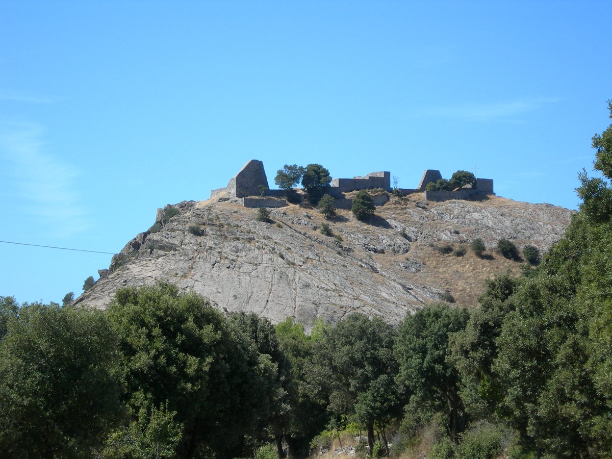 The archaeological site of Casteddu Etzu, located along the SP19 road in the countryside of Cuglieri, represents one of the most significant testimonies of Punic and Roman presence in the Oristano hinterland. This fortified settlement, strategically positioned on a hilltop overlooking the valley, preserves remains of cyclopean walls and residential structures that narrate centuries of history. Excavation campaigns have uncovered Punic ceramics and Roman coins, highlighting continuous settlement from the 4th century BC through the Imperial era. The commanding position offers a panoramic view over Montiferru, allowing visitors to understand the site's strategic importance for territorial control. The findings also include water collection cisterns and building foundations that suggest a complex urban organization.
- SP19, Cùllieri/Cuglieri (OR)
- Open in Google Maps
- View on Google Images
You should go if...
Day 1 - Stop no. 3
Former Pontifical Regional Seminary of Sardinia
 The Former Pontifical Regional Seminary of Sardinia, located on Via Giovanni Spano in Cuglieri, stands as a significant example of Sardinian ecclesiastical architecture. This complex, built in the 17th century as a training center for the regional clergy, is distinguished by its local stone facade and imposing structure that dominates the historic center. The building preserves austere study environments and communal spaces that reflect the seminary life of that era. The internal chapel, with its Baroque decorative elements, offers a glimpse into the devotion and sacred art of central Sardinia. Today, following careful restoration, it hosts cultural events while maintaining its historic character intact. Its location in the heart of Cuglieri allows visitors to appreciate the urban context in which this educational institution developed.
- Via Giovanni Spano, Cùllieri/Cuglieri (OR)
- Open in Google Maps
- View on Google Images
You should go if...
Day 2 - Stop no. 1
Nuraghe Losa
 The Nuraghe Losa rises majestically along State Road 131, just a few kilometers from Abbasanta, representing one of the best-preserved examples of Nuragic architecture in Sardinia. This trilobate complex, dating back to the Bronze Age, features a central tower over 13 meters high, surrounded by three smaller towers connected by curtain walls. The dark basalt structure displays linteled entrances and spiral staircases leading to the upper floors, offering a detailed insight into prehistoric construction techniques. Within the enclosure lies a circular hut village, while the surrounding area preserves traces of giants' tombs and sacred wells, testifying to the site's ritual importance. The strategic location along the ancient road route highlights the territorial control role this nuraghe exercised over the Oristano plain.
- Strada Statale 131 Diramazione Centrale Nuorese, Abbasanta (OR)
- https://www.nuraghelosa.net/
- Open in Google Maps
- View on Google Images
You should go if...
Day 2 - Stop no. 2
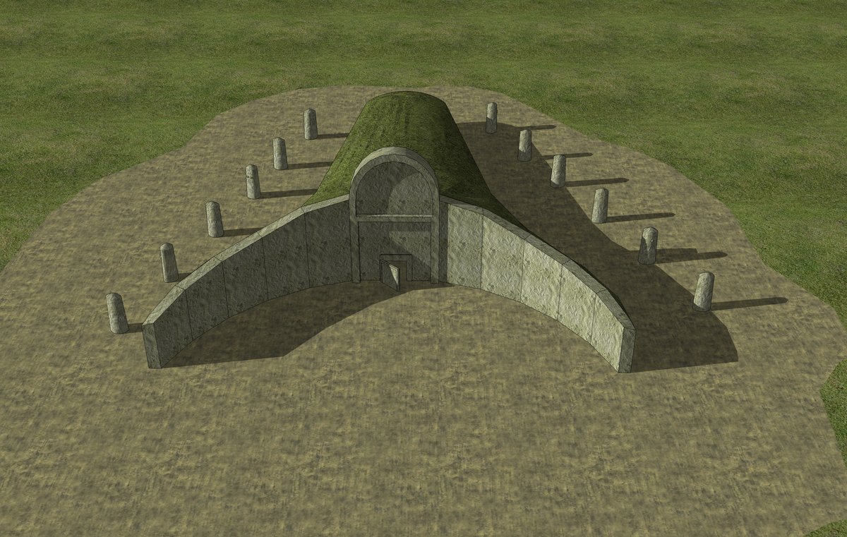
Santa Cristina Well
 The Santa Cristina Well in Paulilatino is one of the most fascinating monuments on the Oristano archaeological itinerary. Built from basalt during the Bronze Age, this Nuragic sacred well features a trapezoidal staircase descending toward the water table, with perfect symmetry that impresses with its architectural precision. The structure is astronomically oriented: during equinoxes, moonlight illuminates the bottom of the well, a phenomenon suggesting advanced knowledge. Surrounding the well extends a Nuragic village with circular huts and a megaron temple, offering a glimpse into the religious and social life of the era. Visiting here enriches the second day of the journey, showing how the nuraghi were not just fortresses but also spiritual centers.
- Strada Statale 131 Carlo Felice, Paulle/Paulilatino (OR)
- Open in Google Maps
- View on Google Images
You should go if...
Day 2 - Stop no. 3
Goronna Giants' Tomb Complex
 Leaving behind the mysterious Well of Santa Cristina, the archaeological route continues towards the Goronna Giants' Tomb Complex, located along the SP11 in the Paulilatino countryside. This Nuragic burial site, dating back to the Middle Bronze Age, stands out for its exedra structure, characterized by basalt slabs arranged in a semicircle that demarcate the burial area. The main tomb, over 10 meters long, preserves part of the arched stele, a central monolith that once reached 4 meters in height, symbolizing the connection between the world of the living and that of the ancestors. Around the burials, the remains of a Nuragic village with circular huts suggest an organized community that honored the deceased with collective rituals. The visit here completes the second day of the itinerary, revealing how the nuraghi were not just dwellings, but also places of memory and tradition.
- SP11, Paulle/Paulilatino (OR)
- Open in Google Maps
- View on Google Images
You should go if...
Day 3 - Stop no. 1
Tharros: The Phoenician-Punic City by the Sea
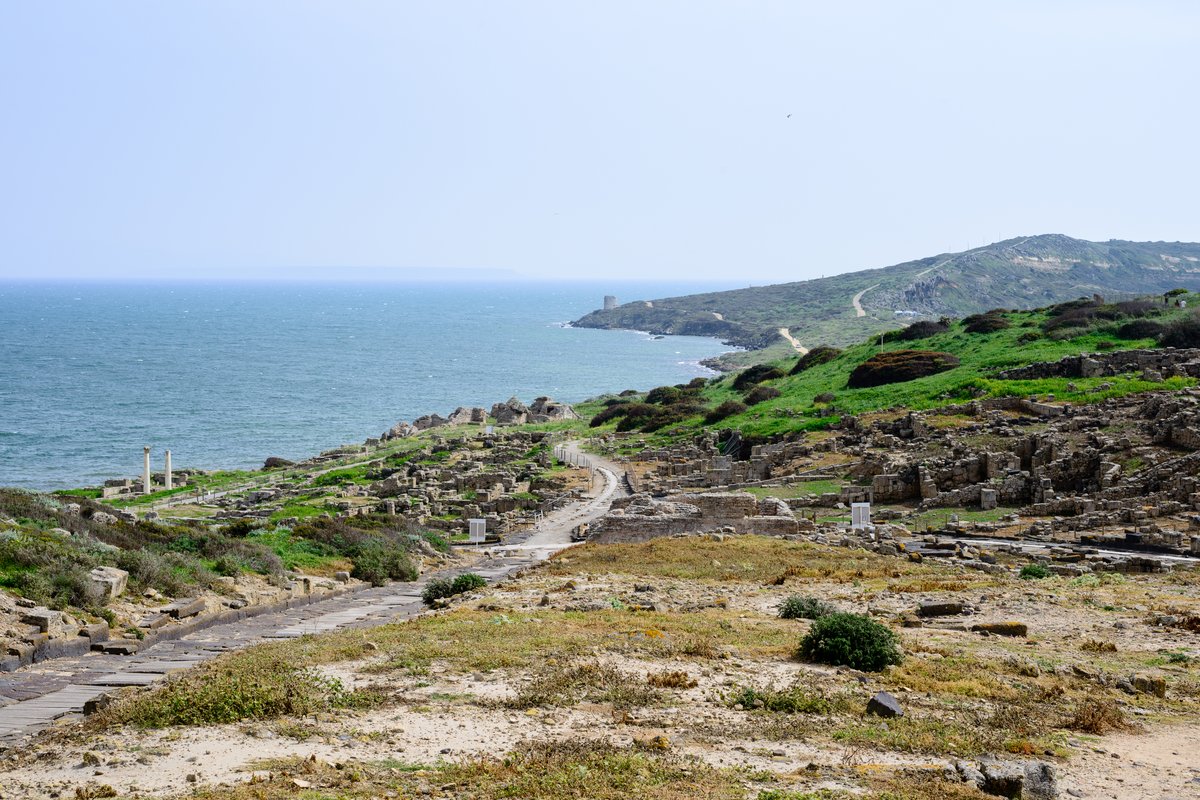 The third day of the archaeological itinerary begins with exploring the Archaeological Area of Tharros, located along the Cardo Maximus in Cabras. This site, founded by the Phoenicians in the 8th century BC and later expanded by the Carthaginians and Romans, stretches across a strategic peninsula between the Cabras Lagoon and the sea. Walking along the main decumanus, you'll observe the remains of Roman baths, with the hypocaust system still visible, and the foundations of the Punic temple dedicated to Melqart. The sandstone columns of the Capitolium and the rainwater collection cisterns testify to the advanced hydraulic engineering. The panoramic position on the Sinis peninsula allows you to imagine the commercial importance of this port, a crossroads between Sardinia, Africa, and the Iberian Peninsula.
- Go to the page: Tharros: Ancient Phoenician-Punic City with Roman Baths and Unique Sardinian Tophet
- Cardo Maximus, Crabas/Cabras (OR)
- https://www.tharros.sardegna.it/
- Open in Google Maps
- View on Google Images
You should go if...
Day 3 - Stop no. 2
Tharros Amphitheatre
 The Tharros Amphitheatre stands on the Cape San Marco promontory, where limestone seating tiers face directly onto the Mediterranean. Built in the 1st century AD, this archaeological site preserves the western hemicycle with vomitoria still accessible, while the cavea could accommodate up to 2,000 spectators. Visitors can observe the remains of the carceres, the cells where gladiators and wild beasts were confined before the shows. The distinctive feature is the fusion of Roman architecture and coastal landscape, with the arena opening towards the Cape San Marco lighthouse. Recent excavations have uncovered coins minted under Emperor Tiberius, confirming Tharros' strategic importance as a trading port. Today, the wind-eroded steps offer a unique view of the Sinis Peninsula seabed, where mullet and sea bass swim.
- Cardo Maximus, Crabas/Cabras (OR)
- http://www.anfiteatrotharros.it
- Open in Google Maps
- View on Google Images
You should go if...
Day 3 - Stop no. 3
San Giovanni di Sinis Tower
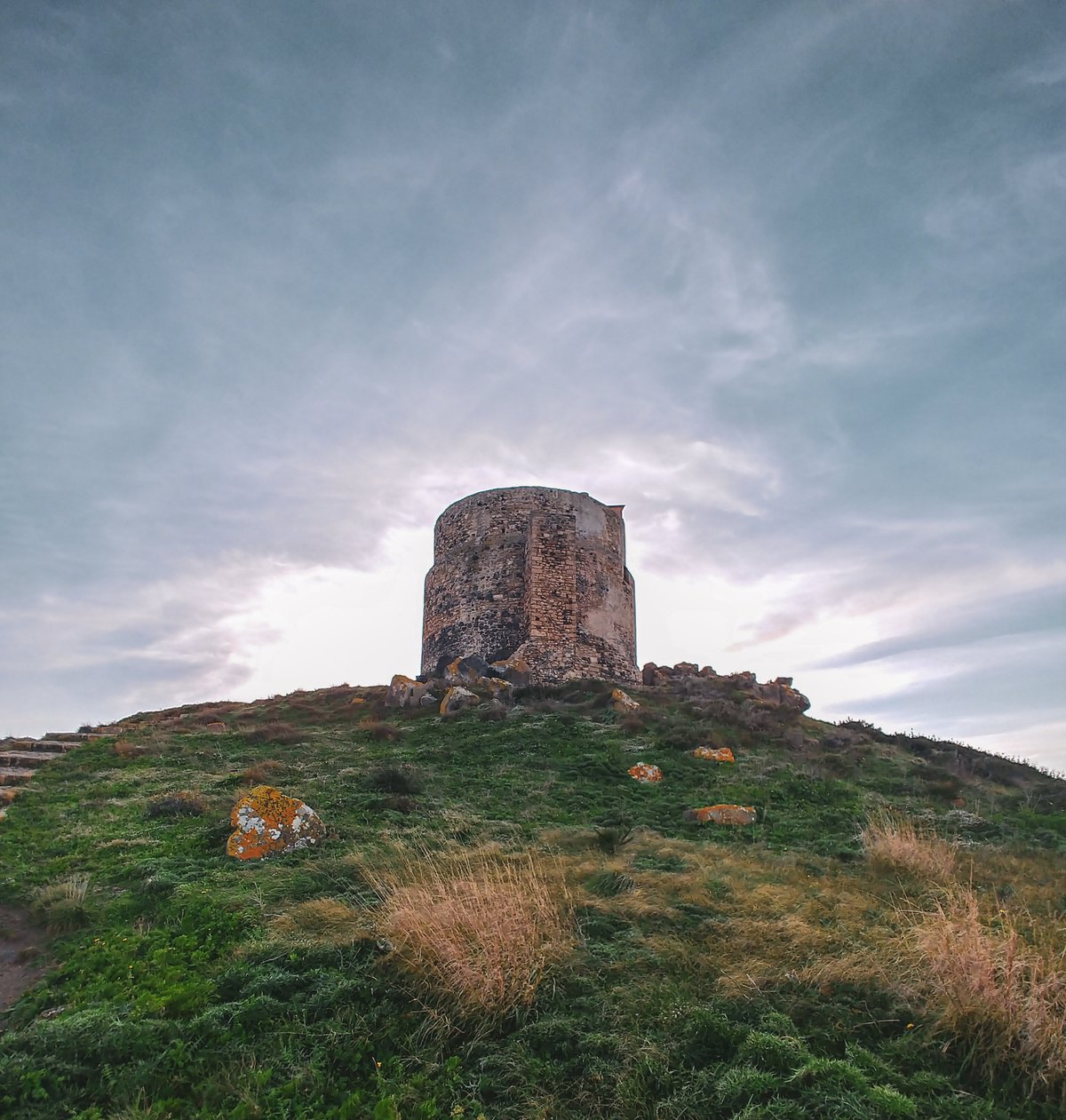 The San Giovanni di Sinis Tower stands tall on the western coast of Sardinia, built in the 16th century as part of the Spanish defensive system against pirate raids. Unlike the Nuragic and Roman structures visited in previous days, this Aragonese tower represents a more recent chapter in Sardinian history, with its circular layout and still-visible loopholes. Strategically positioned on the Capo San Marco promontory, it offers an exceptional panoramic view of the Marine Protected Area of the Sinis Peninsula and the ruins of Tharros below. Visitors can observe the construction technique using local limestone, with wall thicknesses reaching up to 4 meters. The tower served as a lookout point visually connected with Torre Grande and other coastal fortifications, forming a defensive chain that protected commercial harbors. Today, its austere profile contrasts with the deep blue of the Cabras sea, creating a photogenic spectacle especially at sunset.
- Cardo Maximus, Crabas/Cabras (OR)
- Open in Google Maps
- View on Google Images
You should go if...


