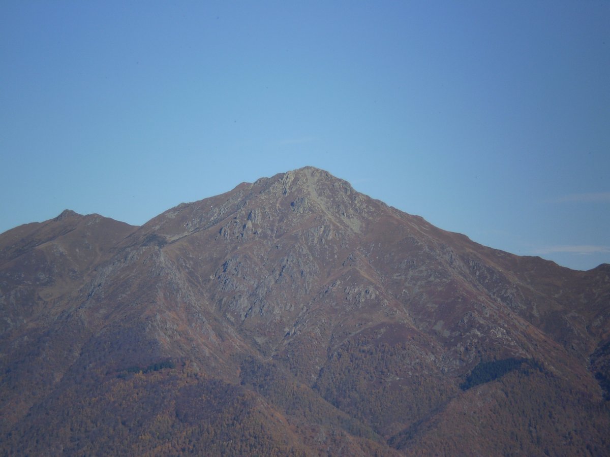
Two hours from Turin, Monte Barone is the ideal destination for a day hike immersed in nature. At 2044 meters, it dominates the Valsessera valley and offers spectacular views. The route starts at Le Piane and winds through forests, streams, and equipped sections.
Elevation gain: 1120 meters
Duration: about 6 hours (round trip)
Difficulty: hiking (E), with a short equipped section
Rest point: Rifugio Monte Barone at 1610 m
Events nearby
A moderately challenging hike in the Biellese Prealps, with a 1120-meter elevation gain and a 360° panorama from Monte Rosa to the plains. The route passes the Rifugio Barone and offers loop options via La Spelonca.
- Strada Vicinale della Pianaccia, Biella (BI)
- Open in Google Maps
- View on Google Images Monte Barone a Biella
Good to know
Introduction
Monte Barone, with its 2044 meters, is the symbol of Valsessera. Once at the summit, the 360° view takes your breath away: from Monte Rosa to the Po Valley, everything seems within reach. It’s not a walk in the park, but the medium-difficulty hike offers authentic emotions, through woods, ridges, and a welcoming mountain hut. Prepare for a 1120-meter elevation gain, but it’s worth it.
Historical Background
The Monte Barone area has a history tied to the textile industry. In the 1930s, Ermenegildo Zegna undertook an environmental and social enhancement project in Trivero, planting thousands of trees and building infrastructure. In 1993, the Oasi Zegna was established, a nature park covering about 100 km² that embraces these mountains. The summit itself has hosted skyrunning and mountain running races, a testament to its sporting appeal.
The trail: nature and adventure
Starting from Le Piane (969 m) in the municipality of Coggiola, the G1/G8 trail enters a birch forest, follows streams, and crosses small bridges. After the Rifugio La Ciota, the climb becomes steeper. A section equipped with fixed ropes (Le Scarpie) requires some caution but can be managed with a steady step. Once at Rifugio Barone (1590 m), you can refresh yourself before tackling the final ridge to the summit.
Panoramic Views from the Summit
From the metal cross, the view stretches 360 degrees. To the north, Monte Rosa dominates with its glaciers; to the south, the plain disappears into the horizon. The Biellese Prealps, Valsesia, and the Aosta Valley mountains frame the scene. At the summit, you’ll find a compass rose to help identify the peaks. It’s the perfect spot for a photo break, perhaps while listening to the little bell of a small Madonna statue just below.
Why Visit It
Three reasons: first, the breathtaking panorama – you’ll rarely find such a complete view of the Alps and the plains. Second, the variety of the trail: woods, meadows, an equipped rocky section, and a welcoming mountain hut. Third, the possibility of a loop passing through La Spelonca, an artistic corner with rock carvings by Ales. Perfect for those seeking a challenging but rewarding hike.
When to Go
The best time? Spring, because the southern exposure makes the snow melt early, and the second part of autumn, until the first snowfall. In summer the trail has little shade and can be very hot. Better to start early in the morning to enjoy the best light and avoid the afternoon heat. Always check the conditions of the equipped section: with ice or snow it becomes dangerous.
Nearby
Two gems: La Spelonca, a quarry turned into a stone refuge with a cable car and poetic inscriptions by Ales, just steps from the loop trail. And the Oasi Zegna, the natural park created by Ermenegildo Zegna, with woods, trails, and outdoor artworks. It’s worth the detour to Trivero to discover the architecture and history of the Lanificio Zegna.
Itineraries nearby


💡 Did You Know…?
Along the trail, you’ll find La Spelonca, a quarry turned into a shelter by a local character nicknamed Ales, who carved poems into the rock. At the summit, a small Madonna statue with a bell and a wind rose accompany the panorama, while the summit logbook holds greetings from hikers.